Japan Plans to Provide Flood Risk Warning Maps for Southeast Asia
 |
| Japan also considers providing similar maps to countries other than the Southeast Asia region. (Photo: TD). |
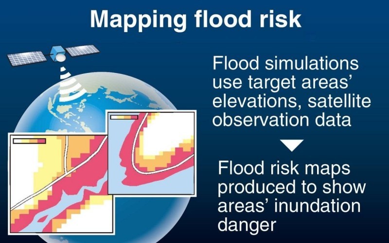
In Japan, flood risk maps are available in various regions of Japan, showing the frequency and depth of flooding caused by floods. Based on observational data collected on the ground, including rain gauges, the maps show that the risk of flooding from heavy rainfall is likely to occur every 10, 30, 50, 100 150 or 200 years, along with information used to facilitate evacuation and community planning.
Vietnam, Indonesia, Thailand, and Cambodia are four Southeast Asian countries often affected by floods. According to the Japanese Ministry of Land, Infrastructure, Transport, and Tourism, these countries do not have enough observational data on the ground. The maps that clearly show flood risk in target areas can provide useful information and support risk prevention and management for the local authorities. Specifically, maps of targeted areas will be created after simulating floods using observational data collected using the Global Satellite Precipitation Map (GSMaP). This system is operated by the Japan Aerospace Exploration Agency and other agencies.
The Japanese side has begun discussions with four countries in fiscal 2023 to select target areas. The agency plans to provide a prototype version of the map to each country by the end of fiscal 2025.
In addition to preparing guidelines including the mapping process, the Japanese Ministry of Land, Infrastructure, Transport and Tourism will also develop human resources through training programs. The maps are expected to be made available to the public in each country.
Many Japanese companies that operate in the above four countries expect to make good use of the flood risk map. It will help them choose office or factory locations and prepare business disaster plans.
Japan also considers providing similar maps to countries other than the Southeast Asia region.
 | Explore The First Astronomy Park In Southeast Asia Located in Duong Noi urban area in Ha Dong District, Hanoi, Astronomy Park is a public project for outer space lovers. |
 | Vietnam Is An Important Partner Of Brazil In Southeast Asia Over the past 35 years, the relationship between Vietnam and Brazil has been developing positively in all fields, becoming more substantive and effective with closer ... |
 | Digital Economic Development Rate in Vietnam is Fastest Among Southeast Asian Countries On April 24, Prime Minister Pham Minh Chinh, Chairman of the National Committee on Digital Transformation, chaired the 8th session of the Committee. The discussion ... |
Recommended
 World
World
Pakistan NCRC report explores emerging child rights issues
 World
World
"India has right to defend herself against terror," says German Foreign Minister, endorses Op Sindoor
 World
World
‘We stand with India’: Japan, UAE back New Delhi over its global outreach against terror
 World
World
'Action Was Entirely Justifiable': Former US NSA John Bolton Backs India's Right After Pahalgam Attack
 World
World
US, China Conclude Trade Talks with Positive Outcome
 World
World
Nifty, Sensex jumped more than 2% in opening as India-Pakistan tensions ease
 World
World
Easing of US-China Tariffs: Markets React Positively, Experts Remain Cautious
 World
World
