A Japanese island keeps growing ten times in size
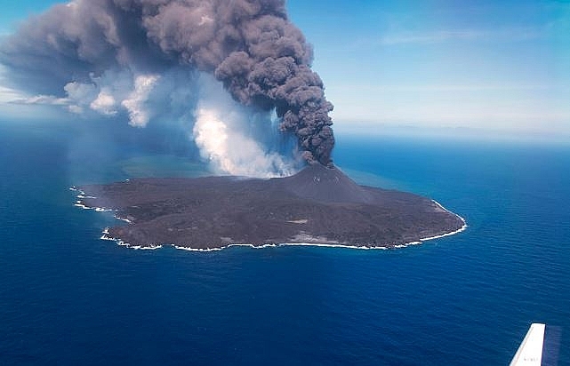 |
| Nishinoshima in June 2020. Photo: Japan Coast Guard |
Nishinoshima is a volcanic island located around 940 km (580 mi) south-southeast of Tokyo, Japan that is part of the Volcano Islands arc. It has also been known as Rosario Island.
Originally the above-water part of the ridge of an underwater caldera, Nishinoshima was enlarged in 1974 after fresh eruptions created a new section of the island. Another eruption that began in November 2013 further enlarged the island and attracted worldwide attention. Volcanic cone soon formed, raising to an estimated height of 142 m (466 ft) by July 2016. The eruptions ceased by November 2015, though emissions of volcanic gases continued for several months afterward.
As of 2016, the island was about 2.7 km2 (1.0 sq mi) in size and evinces the return of various plants and animal species
There were further eruptions in 20172018 and 2019, with the latest eruption continuing as of July 2020. This increased the island size to 2.89 km2 (1.12 sq mi) as of 2019
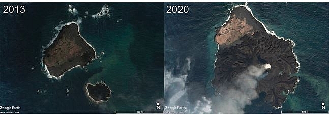 |
| Nishinoshima has been almost doubled after 7 years. Photo: Google Earth |
Kenji Nogami, a volcanologist at the Tokyo Institute of Technology who has been keeping tabs on Nishinoshima since 2013, tells NHK that the volcanic island is positioned squarely above a huge reserve of underground magma. He says this means lava will likely continue to flow, further increasing the island’s size.
According to news reports citing the Geospatial Information Authority of Japan, the southern shore of the island grew by at least 150 meters between June 19 and July 3. The European Space Agency’s TROPOMI satellite also observed a sizable plume of sulfur dioxide from the eruption.
Reports from July 4 revealed that volcanic bombs, or larger fragments of solid and molten material, were ejected up to 1.6 miles (2.5 km) and clouds of ash reached up to 27,200 feet (8,300 meters) — the highest altitude recorded since the volcano emerged in 2013, according to the statement.
The Moderate Resolution Imaging Spectroradiometer (MODIS) on NASA’s Aqua satellite also captured a stunning view of the island's volcanic activity on Monday (July 6). The natural-color image shows a volcanic plume stretching hundreds of kilometers to the north and several thousand meters into the sky.
The growth of Nishinoshima and the evolution of the island's volcanic activity can be viewed online at NASA Earth Observatory with NASA satellite images of the island date back to 2013.
 | Bali shuts airport after volcanic eruption Bali closed its international airport following a volcanic eruption on the Indonesian resort island that sent thick smoke and ash billowing 2,000m into the air, ... |
 | 200 missing as Guatemala volcano threatens new eruptions Explosions boomed from Guatemala's fearsome Fuego volcano on Wednesday (June 6), unleashing fresh torrents of molten mud and ash down slopes where officials said 75 ... |
 | New fissures from Hawaii volcano, more eruptions feared Two new fissures have opened on Hawaii's Big Island, officials said on Monday (May 14th), warning of more lava eruptions and gas emissions from the ... |
Recommended
 World
World
Pakistan NCRC report explores emerging child rights issues
 World
World
"India has right to defend herself against terror," says German Foreign Minister, endorses Op Sindoor
 World
World
‘We stand with India’: Japan, UAE back New Delhi over its global outreach against terror
 World
World
'Action Was Entirely Justifiable': Former US NSA John Bolton Backs India's Right After Pahalgam Attack
 World
World
US, China Conclude Trade Talks with Positive Outcome
 World
World
Nifty, Sensex jumped more than 2% in opening as India-Pakistan tensions ease
 World
World
Easing of US-China Tariffs: Markets React Positively, Experts Remain Cautious
 World
World

