Discover The Weirdest Places Existed Around The World
The Earth is a strange place, with many bizzare, unusual and extraordinary destinations that you can see and visit. Technicolor mountains, otherworldly forests, and glow-in-the-dark beaches: These unusual places around the world prove that weird can also be wonderful. They can be wonderful tourist destinations for people who want to discover new things and have entire new experience.
1. Salar De Uyuni – Explore The White Salt Bed
 |
| Photo: myyen97 |
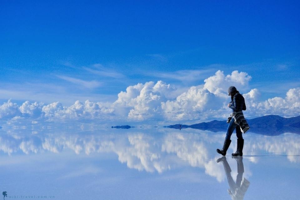
Salar de Uyuni (or "Salar de Tunupa") is the world's largest salt flat, or playa, at over 10,000 square kilometres (3,900 sq mi) in area. It is in the Daniel Campos Province in Potosí in southwest Bolivia, near the crest of the Andes at an elevation of 3,656 m (11,995 ft) above sea level.
The Salar was formed as a result of transformations between several prehistoric lakes that existed around forty thousand years ago but had all evaporated over time. It is now covered by a few meters of salt crust, which has an extraordinary flatness with the average elevation variations within one meter over the entire area of the Salar. The crust serves as a source of salt and covers a pool of brine, which is exceptionally rich in lithium. The large area, clear skies, and exceptional flatness of the surface make the Salar ideal for calibrating the altimeters of Earth observation satellites. Following rain, a thin layer of dead calm water transforms the flat into the world's largest mirror, 129 km (80 mi) across.
The Salar serves as the major transport route across the Bolivian Altiplano and is a prime breeding ground for several species of flamingos. Salar de Uyuni is also a climatological transitional zone since the towering tropical cumulus congestus and cumulonimbus incus clouds that form in the eastern part of the salt flat during the summer cannot permeate beyond its drier western edges, near the Chilean border and the Atacama Desert.
2. Socotra, Yemen
 |
| Photo: BBC |
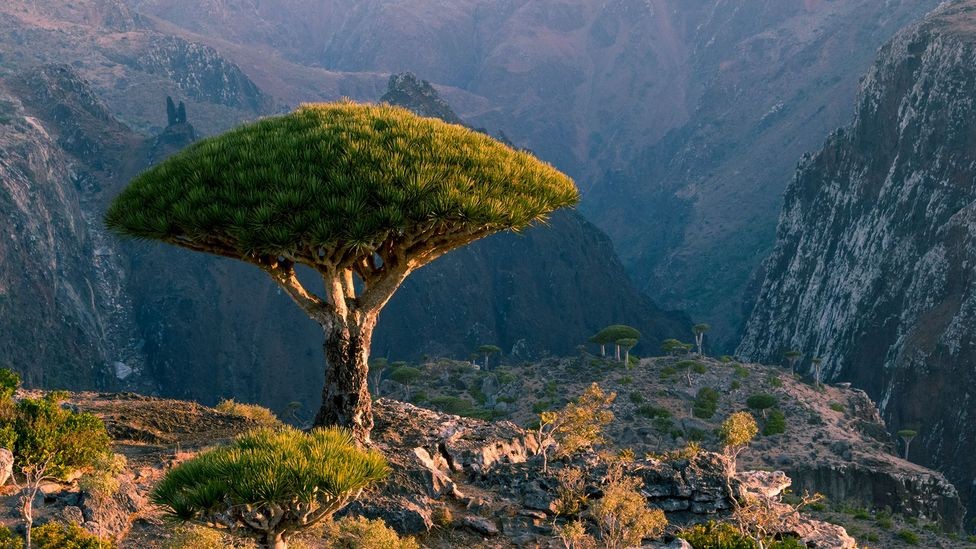
Socotra or Soqotra, between the Guardafui Channel and the Arabian Sea, is the largest of the four islands in the Socotra archipelago. The territory is near major shipping routes and is officially part of Yemen, and had long been a subdivision of Aden Governorate. In 2004, it became attached to the Hadhramaut Governorate, which is much closer to the island than Aden (although the nearest governorate was the Al Mahrah Governorate). In 2013, the archipelago became its own governorate: Socotra Governorate.
The island of Socotra constitutes around 95% of the landmass of the Socotra archipelago. It lies 380 kilometres (240 mi) south of the Arabian Peninsula. While politically a part of Yemen, which is located on the Arabian Peninsula and thus part of Western Asia, Socotra and the rest of its archipelago is a continental fragment that is geographically part of Africa. The island is isolated and home to a high number of endemic species. Up to a third of its plant life is endemic. It has been described as "the most alien-looking place on Earth." The island measures 132 kilometres (82 mi) in length and 49.7 kilometres (30.9 mi) in width. In 2008 Socotra was recognised as a UNESCO World Heritage Site.
3. Zhangye Danxia Landform: Gansu, China
 |
| Photo: Beijing Hikers |
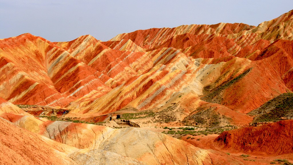
Zhangye Danxia National Geological Park is in the eastern foothills of the Qilian Mountains in Gansu Province, China. The geological park has a spectacular Danxia landform area that covers about 50 square kilometers (19 square miles).
The danxia landforms are a masterpiece of nature. The colorful mountain ridges are just like an overturned palette from heaven.
Zhangye's Danxia landscape has lots of precipitous red cliffs, most of which are several hundred meters high, and multicolored ridges of weathered strata, sometimes stretching to the horizon. These formations, sometimes smooth sometimes sharp, stand out against the greens or grays of the plains , looking grand and magnificent, vigorous and virile.
Across the danxia landscape zone, a kaleidoscope of numerous red rocky outcrops resemble weird and wonderful shapes like castles, cones, towers; as well as humans, creatures, birds and beasts. Their peaks peeping through the mist and clouds, produce mirage-like scenery of fantastic mountains and pavilions.
About 540 million years ago, the area was once part of the ocean. Due to tectonic plate collision, the land folded and formed mountains, and lifted above sea level.
Red sandstone was deposited when rivers formed in the area. When the ground sank into a basin, mudstone was deposited on the red sandstone. During different periods, varying sedimentary rocks were formed that contained different amounts of ferrous salt in the mud and stone. This is why the layers have different colors.
Because of the changes in sedimentary environments, the sedimentary layers formed have different colors of red, purplish red, yellowish green, grayish green, and gray. Every layer took thousands of years to form.
The movement of the Himalayas lifted the area higher and rivers formed. The river erosion formed gorges, and the early Danxia landscape was created. After further geological periods, river erosion and wind erosion formed the colorful layers we see today, according to China Highlights.
4. Pamukkale: Denizli, Turkey
 |
| Photo: Living + Nomads |
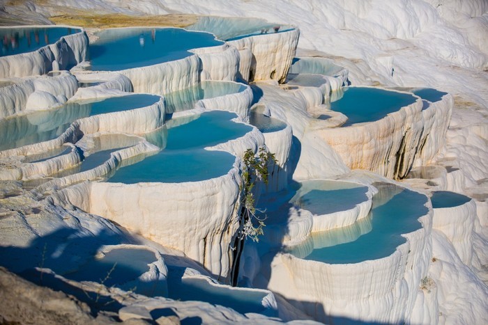
In Turkish Pamukkale means ‘Cotton Castle’. The city is located in the inner Aegean region, in the River Menderes Valley. Tectonic movements on the basin of the Menderes River triggered the rise of multiple hot springs. The water from these springs contains a large mineral content, with chalk, limestone and travertine cascading down the mountain, giving rise to the complexion of the mountains; resembling a frozen waterfall. The waters contain a large amount of hydrogen carbonate and calcium, which results in the precipitation of calcium bi-carbonate. For details on tours, visit our Pamukkale tour page that include 1 and 2 day bus tours from Cappadocia to Ephesus. You can also visit our broader Cappadocia region tours for some great holiday options.
The combination of all the above attribute, make the landscape surreal and Pamukkale is on the World Heritage list. Long before this listing, the Romans recognised this appeal and built a spa city, Hierapolis.
5. Rakotzbrücke (Rakotz Bridge): Kromlau, Germany
 |
| Photo: Christine Abroad |
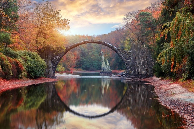
Rakotzbrücke, also called the Devil’s Bridge, looks like something that belongs in a fairytale.
This unique looking bridge is tucked away in a small park in Saxony, Germany. Getting here can be a challenge, since Rakotzbrücke is not located near any major city. However, if you combine a trip here with other nearby destinations, you can turn this visit into a wonderful day trip.
Numerous Devil’s Bridges were built during medieval times. These bridges are masonry bridges that are either so spectacular or so challenging to build that only the devil could have helped with their construction. The legend goes that the devil helps to build the bridge in exchange for soul of the first human who crosses the bridge. Each bridge has its own unique folktale.
Rakotzbrücke was built in 1860 by human hands. The entire bridge is manmade, including the jagged, rocky spires on either end of the bridge and the pointed rocks that sit out in the lake. Even though Satan did not play a role in the construction of this bridge, it still gets the name Devil’s Bridge for its delicate arch. It’s so extraordinary that Satan must have built it.
6. Valle de Cocora: Quindío, Colombia
 |
| Photo: Expotur |
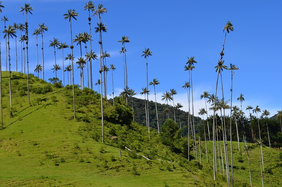
The Cocora valley (Spanish: Valle del Cocora) is a valley in the department of Quindío in the country of Colombia. It is located in the Central Cordillera of the Andean mountains. "Cocora" was the name of a Quimbayan princess, daughter of the local chief Acaime, and means "star of water" (Spanish: estrella de agua).
The valley is part of the Los Nevados National Natural Park, incorporated into the existing national park by the Colombian government in 1985. It is the main location where the national tree of Colombia, the Quindío wax palm (Ceroxylon quindiuense) can be found, as well as a wide variety of other flora and fauna (some endangered), all of which are protected under the park's national status.
The Cocora valley is located on the upper reaches of the Quindío River, the main river of the namesake department, located at an altitude between 1800 and 2400 meters. The valley is approximately 24 km north-east of the departmental capital Armenia, and accessed via a junction from the Armenia-Pereira highway, running via Boquia to the town of Salento. Vehicles (either private cars or jeep taxis from Salento) can then travel 11 km further on up into the valley as far as "Cocora", a collection of campsites and restaurants - other parts of the valley can only be accessed either by hiking on the numerous trails or on horseback.
The Cocora valley is part of a larger national park, the Los Nevados National Natural Park (Spanish: Parque Nacional Natural de Los Nevados). The park covers an area of 58,000 hectares (580 km2) in total, including the north-eastern part of Quindío.
7. Mendenhall Ice Caves: Juneau, Alaska
 |
| Photo: The Adventures of Nicole |
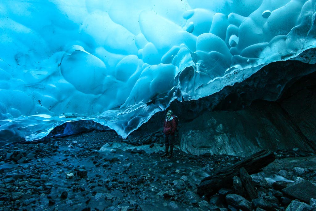
The Mendenhall Glacier is a 12-mile-long glacier in the Mendenhall Valley, only 12 miles from downtown Juneau in southeast Alaska. The glacier originally had two names: Sitaantaagu (“Glacier Behind the Town”) and Aak’wtaaksit (“Glacier Behind the Little Lake”). Inside the glacier are the stunning blue ice caves, accessible only to those willing to kayak to the edge of the ice and then climb over the glacier.
Sadly, this Juneau glacier is retreating increasingly fast as climate change warms the ocean. The Mendenhall Glacier has receded almost two miles since 1958, while previously it had receded only 0.5 miles since 1500. The ice caves are in part a function of this glacial melting. Images of the caves circulate the internet with such captions as “otherworldly” and “surreal,” but “shrinking” and “fleeting” could be used as well, as this glacier creates incredible ever-changing landscapes while we watch it melt away, according to Atlas Obscura.
 | Visit The Mesmerizing Vipava Valley, The Treasure of Slovenia One of the most favorite and gorgeous tourist destinations of Slovenia, Vipava Valley, is a hidden treasure that charms every tourist coming to the place. |
 | Norway: Top 10 Tourist Destinations That You Can Not Miss Majestic mountains, peaceful towns, long and challenging hiking routes, Norway is considered an ideal tourist destination for adventurers, aspiring photographers, and people who are seeking ... |
 | Best Places To Go For A New Year’s Eve In The United States New Year's Eve is only several hours away, and it is time to pack your suitcase, plan your trip and enjoy your holiday at one ... |
Recommended
 World
World
US, China Conclude Trade Talks with Positive Outcome
 World
World
Nifty, Sensex jumped more than 2% in opening as India-Pakistan tensions ease
 World
World
Easing of US-China Tariffs: Markets React Positively, Experts Remain Cautious
 World
World
India strikes back at terrorists with Operation Sindoor
Popular article
 World
World
India sending Holy Relics of Lord Buddha to Vietnam a special gesture, has generated tremendous spiritual faith: Kiren Rijiju
 World
World
Why the India-US Sonobuoy Co-Production Agreement Matters
 World
World
Vietnam’s 50-year Reunification Celebration Garners Argentine Press’s Attention
 World
World


