UK and Europe daily weather forecast latest, March 27: Outbreaks of drizzle and low cloud affect hills of southern England and Wales


UK's weather forecast
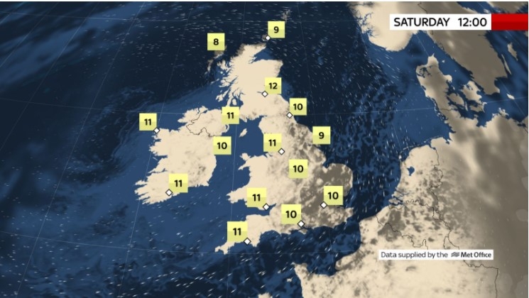
According to Sky News, Saturday will see early showers clearing to leave most places fine, but rain and hill snow will affect the West later. It will stay on the cold side, but lighter winds mean it won't feel too bad in the sunshine.
Sunday looks milder, but it will be windy with some rain in the South. And it's looking warm for some early next week, with 21C (70F) possible in southeast England on Tuesday, but the Easter weekend is likely to be colder.
South-west Europe is predicted to see temperatures soar next week, with France potentially experiencing a sizzling 25C. The UK could also get a taste of the European heat plume, as maps from Weather Outlook show south-eastern regions England including Essex and Kent reaching 17C on Tuesday, March 30. London could reach 16C on the same day, while Bristol and Swindon see 13C, Express reported.
Brian Gaze, a forecaster at Weather Outlook, said temperatures could even hit 18C on Monday and Tuesday. March's average temperatures in the UK are between 7 and 11C.
But Brian Gaze, a forecaster at Weather Outlook, warned the warm air is unlikely to last for long as cold air is forecast to blast the UK by the end of the week, as April arrives.
 |
| Photo: Sky News |
He wrote on Twitter: "GFS06z shows warm conditions across much of western Europe early next week with 25C reached in south western France. Colder conditions then return over the Easter weekend."
Mr Gaze explained further in a longer forecast that "snow could return" next week as the cold air moves in.
He said: "On Monday and Tuesday the north remains chilly and showery. Southern and central counties have patchy rain but also bright periods. It may become very mild in the south with temperatures possibly reaching 18C (64F). During the rest of the week, high pressure is forecast to build to the west. That leads to the likelihood of cold air moving southwards over the UK. It may turn notably cold for the time of year and the risk of sleet or snow could return."
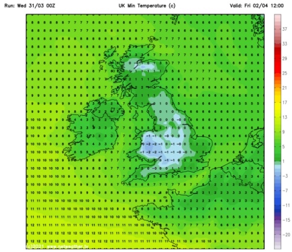
Temperatures could drop to -5C in Scotland on Monday, April 5, according to WXCHARTS. The rest of England could also see single figures over the Easter Weekend, with 0C hitting Cumbria and Newcastle and -2C blasting Manchester elsewhere in the north. South-eastern areas including London and Southampton may average 1C.
The BBC's long-range forecast between Monday, March 29, and Sunday, April 4, added southern and eastern regions are expected to see drier and warmer air while northern regions "bear the brunt" of more brutal conditions.
The forecast said: "For the final few days of March and start of April, including the Easter bank holiday weekend, the unsettled pattern is expected to continue. This is due to high pressure building away to our southwest near the Azores and to the east from Turkey into Russia."
"As we are sat between these two high pressure systems, lower pressure is expected for the UK and the storm track is likely to remain influential over Northwest Europe."
"This means it will likely continue to be wet and windy as weather fronts sweep in from the west or northwest. As such, western and northern areas will bear the brunt of the weather, while southern and eastern areas tend to run a bit drier. Temperatures will also continue to be fairly changeable over the course of next week."
"Southwest winds are expected to bring some warmer sub-tropical air from the Atlantic into the area for the first half of the week, with temperatures trending well above average for a few days. Southern England may see highs climb into the mid-teens in places."
") |
| UK weather forecast: Maps show the warm air sweeping across southern England (Image: WEATHER OUTLOOK) |
The Met Office also predicted wintry conditions in the north by the end of next week.
The long-range forecast between Tuesday, March 30 and Thursday, April, 8, added: "Mild to very mild and largely dry in the southeast at first, with cloud and further spells of heavy rain in the north. There are signs that high pressure will then build to the west of the UK clearing cloud and rain southwards through Wednesday whilst introducing colder and clearer conditions across the UK."
"This is likely to bring sunshine and showers to the north and along the east of the UK with these showers turning wintry over high ground, especially in the north. Further south and west conditions will be largely dry and bright. After a mild start in the south temperatures trending towards average to below average for the time of the year. Feeling rather cold especially when exposed to a brisk north wind."
On March 27
According to Weather Online, a weak ridge of high pressure brings a brighter start to the day over much of the country, although some cloud and outbreaks of drizzle and low cloud affecting hills of southern England and Wales. The best of the sunshine in eastern areas. Cloud increases through Ireland and western Scotland bringing rain for the afternoon, this turning more persistent in western Ireland with the winds increasing to gale force. Drizzle over high ground of northwest England and western Wales as well as southwest England later. Highs at 6 to 10C, feeling colder in the wind.
Showers easing through the morning, most places becoming dry with sunny spells. Thicker cloud and outbreaks of rain spreading to the northwest later. Breezy with coastal gales in northwest later, Met Office reported.
 |
| Photo: Weather Online |
Outlook for Sunday to Tuesday
Cloudy and windy with persistent rain across many western hills Wales northwards. Mostly dry across the south and increasingly warm. Windy with gales across many coasts and hills, easing Tuesday.
Europe's weather forecast
Fair for most of Spain and Portugal with lots of sunshine. More sunshine through the central Mediterranean and most of northern Italy, but there will be some showers in southern Italy. Heavy showers and periods of rain affecting southern and eastern parts of Greece. Remaining unsettled across Turkey with further heavy showers here.
Rather cloudy with some outbreaks of rain across central parts of France. Brighter to the north with scattered showers. Fair in the south with lots of sunshine. Cloud and some outbreaks of rain affect the Netherlands, central and northern Germany with southern Germany been dry and sunny. Poland, Hungary, Austria and Switzerland will all be dry with lots of sunshine.
Some cloud affecting Denmark and a few spots of rain to through Thursday. This cloud and spots of rain will also affect southern parts of Sweden and the Baltic states. Rather cloudy across Finland but brighter for Sweden with sunny spells. Cloud and some outbreaks of rain and drizzle affecting western parts of Norway.
 |
| Photo: Stirimteo |
On March 27
According to Weather Online, a dry and bright day for much of Spain and Portugal. Some cloud over central areas extending to the Balearic Islands. Some cloud and isolated showers for northern parts of Italy, staying drier further south. A dry day with plenty of sunshine for Greece and Turkey.
A band of rain clears through eastern France, Germany and Switzerland through the morning leaving brighter conditions with scattered showers to the northwest. Showers also affecting the Low Countries. Rain spreads from west to east over Austria, the Czech Republic and Poland becoming increasingly light and patchy further east. A dry start for Slovakia and Hungary with rain arriving here later.
A wet start for Denmark though rain turns to showers later. Rain then spreads across southern Sweden and into the southern Baltic States. Dry and bright to start for the northern Baltic States and Finland but cloud thickens here later. Patchy outbreaks of rain and sleet affect much of Norway.
 |
| Photo: Weather Online |
 | UK and Europe daily weather forecast latest, March 23: Largely fine with cloudy and breezy conditions, rain to move into western Scotland, Ireland and Northern Ireland Tuesday will be largely fine, if rather cloudy and breezy, but rain over the Atlantic will move into western Scotland, Ireland and Northern Ireland later. ... |
 | UK and Europe daily weather forecast latest, March 22: Mainly dry day with variable cloud and spells of sunshine in the UK The UK is forecasted to have a mainly dry day with variable cloud and some spells of sunshine. Meanwhile, high pressure is expected into western ... |
 | UK and Europe daily weather forecast latest, March 21: Cloudy weather to continue while most places be dry The UK is forecasted to have a cloudy day but most places will be dry with light winds. Meanwhile, heavy rain is expected to cover ... |
Related Stories
 National
Vietnam News Today (May 11): Vietnam, Austria to Boost Cooperation in High-Tech Development, Innovation
 Overseas Vietnamese
Vietnam Young Entrepreneurs Association in Europe Debuts
Recommended
 World
World
Thailand Positions Itself As a Global Wellness Destination
 World
World
Indonesia Accelerates Procedures to Join OECD
 World
World
South Korea elects Lee Jae-myung president
 World
World
22nd Shangri-La Dialogue: Japan, Philippines boost defence cooperation
 World
World
Pakistan NCRC report explores emerging child rights issues
 World
World
"India has right to defend herself against terror," says German Foreign Minister, endorses Op Sindoor
 World
World
‘We stand with India’: Japan, UAE back New Delhi over its global outreach against terror
 World
World