UK and Europe weather forecast latest, December 22: Low pressure and wintry conditions to cover the UK amid freezing air
UK's weather forecast
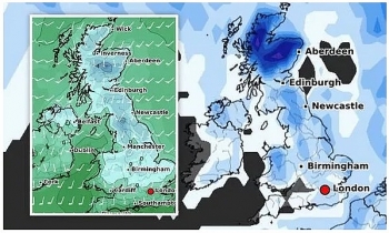
Low pressure is forecast to sweep over the UK this week from the North Atlantic, potentially pushing wintry conditions as far as South East England. Central parts of Scotland could be hit with snow depths of eight inches on Christmas Day, according to WXCHARTS' latest models. Temperatures could also plunge as low as -5C in the same region on Friday, December 25 as cold air lingers throughout the week.
The fierce chill is expected to hit northern parts of England by Friday, with Carlisle forecast to see -3C and Scarborough could see 0C. Southern regions of England are likely to stay in single figures, with London and Plymouth left shivering at 1C. Gavin Partridge, owner of GavsWeatherVids, predicted the cold front to "flood the country" on Christmas Eve.
It said: "On Wednesday, December 23, cold winds from the north begin to dig into Scotland, with low pressure across England and Wales still bringing relatively mild temperatures and some outbreaks of rain would be very probable."
"It is going to be a wet early part of next week, with Monday, Tuesday and Wednesday going to bring quite a lot of rain particularly to central parts of England and Wales. It is drier and colder across Scotland and showers could be turning wintry in central and northern parts of Scotland."
 |
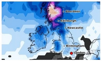
| UK snow forecast: Britain is bracing for a deep freeze on Christmas Day (Image: WXCHARTS) |
The forecast added Britons could wake up to a "white, crunchy" Christmas Day as frost is expected to arrive. The forecast said: On Christmas Eve, the low pressure moves away to the east and we pull in this cold north to north easterly wind.
"Temperatures show it will turn cold across all parts of the country on Christmas Eve as -5C is flooding the country from the north. There's a possibility that the rain may have a wintry flavour on its back, it just depends whether we get an undercut of the cold air from the north."
"The general idea is outbreaks of rain in the south and east to begin with, moving away to the east, then brighter skies pushing down from the north. In those brighter skies there could be wintry showers running down the east coast and snow showers to low levels probably."
"Christmas Eve will be cold this year if the forecast is correct. It's likely to go frosty overnight into Christmas Day, which should lead to a nice white, crunchy start on Christmas Day. Most places in the UK look like they will have a cold Christmas Day but with plenty of sunshine."
"There's a possibility of wintry showers down the east coast, with a possibility in the south east of England."
 |
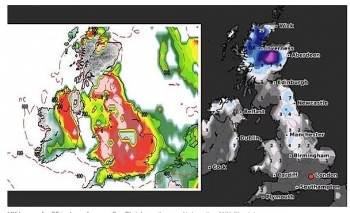
| UK snow forecast: Scotland could see eight inches of snow (Image: WXCHARTS) |
The BBC's long-range forecast added Christmas Day could see wintry showers due to the north-westerly flow. The forecast said: "The first half of this week will continue in the same vein as the previous week, with additional low pressure areas continuing to track north-eastwards over the UK."
"Because we have relatively high pressure to the north of the UK, the north Atlantic low pressure track is displaced a bit further south than where it would normally be in December."
"By Christmas Eve and Christmas Day, confidence is growing for at least a couple of days of colder and brighter weather, as winds change to a north-westerly direction and a ridge of high pressure then moves in from the west."
"Scattered wintry showers in this north-westerly flow may fall as snow, raising the possibility of a white Christmas in parts of the UK!"
"Scotland and the hillier parts of northern England and Wales stand the best chance. Stay tuned to the forecast over the next few days. Some sunshine by day, but a frost is very likely at night for many places."
 |
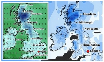
| UK snow forecast: The cold front could push along the east of the UK (Image: GavsWeatherVids) |
The Met Office added a low pressure system could strike between Friday, December 25 and Sunday, January 3. The forecast said: " Atlantic low pressure systems could bring potentially stormy weather at times, with strong northerly winds, heavy rain, and potentially snow. These conditions being more severe in the north but could affect all areas of the UK at times. Temperatures either close to or below average for the time of year."
On December 22
According to Weather Online, outbreaks of rain continue to affect southern parts of England before another area of low pressure tracks across Ireland, England and Wales later. This brings the threat of some further heavy rain to the south though most of the rain elsewhere will be light and patchy. Brighter and colder for Northern Ireland and Scotland as well as the far north of England with some showers affecting western coasts and hills. Highs at 10 to 13C in the far south of England and Wales; more widely 4 to 7C for most.
 |
| Photo: Weather Online |
Europe's weather forecast
Some cloud and patchy rain for northern Iberia, otherwise a dry and fine day across Portugal and Spain. Isolated showers possible for the Balearic Islands, Corsica, Sardinia, Sicily and southern Italy though it will stay largely dry and sunny. Dry and bright too for much of Italy. Variable amounts of cloud around for Greece and Turkey with isolated showers for western Greece and northern Turkey.
Rain, some of this heavy, spreads across France, the Low Countries and into western Germany and Switzerland on Monday. Staying dry and bright to the far southeast of France. Winds strengthen here too. Cloud thickens over eastern Germany, Austria and the Czech Republic though it stays dry. Staying dry and fine further east for Poland, Slovakia and Hungary.
Starting dry and fine for Denmark though cloud thickens, winds strengthen and rain arrives later. Mostly dry and fair for the Baltic States with patchy rain or showers at times, mainly over coastal areas. Patchy outbreaks of rain affect Finland while Sweden sees a mostly dry and fine day. Outbreaks of rain, sleet and snow affect southwest Norway through the day, staying mostly dry and fair across the rest of the country.
 |
| Photo: Stirimeteo |
 |
| Photo: Stirimeteo |
On December 22
Some cloud and rain affect the far northwest of Spain on Tuesday. A dry and fair day across the rest of Spain, Portugal, the Balearic Islands, Corsica, Sardinia, Sicily and Italy with variable amounts of cloud around. More cloud around for Greece where there will also be a scattering of showers. Dry and fine for western Turkey while eastern areas see patchy rain and snow.
Outbreaks of rain for northern France and the Low Countries. These becoming heavy later. Staying dry but increasingly cloudy for southern France. Rain also sweeping eastward across Germany and into Poland later. Patchy rain also affects Switzerland, Austria, the Czech Republic, Hungary and Slovakia.
 |
| Photo: Weather Online |
Early rain clears from Denmark to leave a dry and fine day here. After a dry and fair start, an area of rain, sleet and snow arrives over the Baltic States through the afternoon. An area of rain, sleet and snow also spreads northward over Norway and Sweden, only the far north staying dry. This also spreads over Finland too but not arriving here until later in the afternoon.
 | UK and Europe weather forecast latest, December 18: Conditions turn colder with snow over northern hills for Christmas A white Christmas with snow and freezing temperatures are forecasted in the UK as a cold northerly flows from the Artic. Meanwhile, fair conditions is ... |
 | UK and Europe weather forecast latest, December 17: Bitterly cold air brings wintry conditions and snow to cover the UK The UK is forecasted to cope with bitterly cold weather carrying wintry conditions and snow to cover over the festival period. Meanwhile, heavy rain sets ... |
 | UK and Europe weather forecast latest, December 16: Strong wind and a band of squally rain to cover western parts of the UK The UK is forecasted to bear strong wind and a band of squally rain in many parts, especially in western areas. Meanwhile, weather conditions stay ... |
Related Stories
 National
Vietnam News Today (May 10): Vietnamese Peacekeepers Honored with UN Medal in South Sudan
 National
Vietnam News Today (May 9): Vietnam Ready to Work With Russia to Elevate Relations
Recommended
 World
World
Pakistan NCRC report explores emerging child rights issues
 World
World
"India has right to defend herself against terror," says German Foreign Minister, endorses Op Sindoor
 World
World
‘We stand with India’: Japan, UAE back New Delhi over its global outreach against terror
 World
World
'Action Was Entirely Justifiable': Former US NSA John Bolton Backs India's Right After Pahalgam Attack
 World
World
US, China Conclude Trade Talks with Positive Outcome
 World
World
Nifty, Sensex jumped more than 2% in opening as India-Pakistan tensions ease
 World
World
Easing of US-China Tariffs: Markets React Positively, Experts Remain Cautious
 World
World