India daily weather forecast latest, February 28: Scattered rains, snow and thunderstorms to cover Sikkim, Arunachal Pradesh


According to The Weather Channel’s met team, a cyclonic circulation is currently located over Northeast India, with the system likely to persist at least for the next five days. Under its influence, scattered rain/snow and thunderstorms are expected over both Sikkim and Arunachal Pradesh in this forecast period, Weather.com reported.
Within Sikkim, the regional meteorological centre located in Gangtok has predicted rain/snow—particularly at higher altitude locations—at a few places across East and North Sikkim, and at one or two places in West and South Sikkim on Saturday and Sunday.
Come Monday, the conditions across the northeastern state are likely to become more widespread, covering many places in East and North Sikkim, and a few places across West and South Sikkim.
As for Arunachal Pradesh, the IMD has forecast the aforementioned conditions, along with thunderstorms and lightning, over the districts of Dibang Valley, Upper Siang, West Siang, West Kameng and Papum Pare on Saturday, and East Kameng, Lower Subansiri and Lohit on Sunday.
Thereafter, these conditions will be focused on West Kameng, Papum Pare, Upper Siang, Dibang Valley and Lower Dibang Valley districts on Monday; across Upper Siang, East Siang, West Siang, Dibang Valley, Lower Dibang Valley and West Kameng on Tuesday, and lastly, Upper Siang, East Siang, West Siang, Dibang Valley and East Kameng on Wednesday.
 Weather.com") |
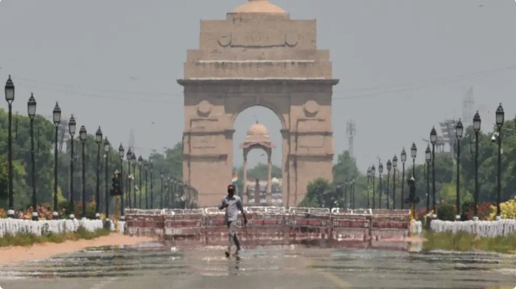
| Representational image (SL Shanth Kumar/BCCL Chennai) Weather.com |
While this region experiences wet conditions, the minimum temperatures across Northeast India will be warmer than normal on Saturday and Sunday, The Weather Channel’s forecast adds.
In the past 24 hours, meanwhile, rainfall and thundershowers were observed at isolated places over Sub-Himalayan West Bengal and Sikkim, as per IMD records.
As far as the seasonal precipitation is concerned, both Sikkim and Arunachal Pradesh have experienced below-average rainfall since the beginning of 2021. Between January 1 and February 27, Sikkim recorded 46.6 mm rains, a 53% ‘deficit’ compared to its long-term average, whereas Arunachal registered 36.2 mm precipitation, a 74% ‘large deficit’ compared to its normal.
According to IMD, under the influence of a Western Disturbance as a cyclonic circulation over north Pakistan & neighbourhood, fairly widespread rainfall/snowfall is very likely to occur over Jammu, Kashmir, Ladakh, Gilgit, Baltistan & Muzaffarabad and scattered rainfall/snowfall over Himachal Pradesh and Uttarakhand during next 24 hours; and isolated rainfall/snowfall over these region during subsequent during next 24 hours.
Isolated thunderstorm/lightning and hail very likely over Jammu, Kashmir, Ladakh, Gilgit, Baltistan & Muzaffarabad, Himachal Pradesh & Uttarakhand during next 24 hour.
Traffic on the Jammu-Srinagar national highway was suspended on Saturday after heavy rains triggered landslides along the Ramban-Ramsoo stretch, officials said.
 |
| Photo: IMD |
The authorities concerned said that the restoration work on the highway will resume once the rain stops completely.
"Landslide debris clearance will start as soon as the rain stops," an official stated.
Meanwhile, the India Meteorological Department (IMD) has forecast that fairly widespread to widespread rainfall/snowfall are likely to continue over Jammu, Kashmir, Ladakh, Gilgit, Baltistan and Muzaffarabad over the next 24 hours, with isolated thunderstorms, lightning and hail also on the horizon.
In view of these predictions, the union territory of Jammu & Kashmir will also remain under an orange alert on Saturday, with the advisory instructing residents to 'be prepared' for rough weather conditions.
Rain or thundershower is most likely to occur at one or two places in Kerala and dry weather is most likely to prevail over Lakshadweep. Besides, thunderstorm accompanied with lightning is very likely to occur at one or two places in Kerala on 27th & 28th February 2021, IMD reported.
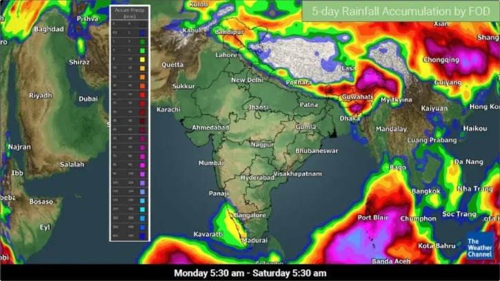
5-Day Nationwide Weather Forecast
According to Weather Online, a western disturbance and induced cyclonic circulation are located over North Pakistan and adjoining areas on Saturday, all set to affect the weather across the Western Himalayan Region. The systems could bring fairly widespread snow or rain with thunderstorms over Jammu & Kashmir and Ladakh; and scattered snow or rain with thunderstorms over Himachal Pradesh and Uttarakhand on Saturday.
. Weather.com") |
| File photo (IANS). Weather.com |
Further, a fresh western disturbance is also forecast to affect the Western Himalayan Region from Wednesday onwards.
Meanwhile, a cyclonic circulation is likely to persist over Northeastern India in this period, and produce isolated to scattered snow or rain and thunderstorms over Northeastern India. Scattered snow or rain with thunderstorms are expected over Arunachal Pradesh in this period, while scattered snow or rain with thunderstorms are possible over Sikkim from Saturday to Monday.
Isolated rain with lightning is on the cards over Kerala on Saturday. Dry weather is likely over other areas in this forecast period.
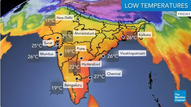
Maximum temperatures are expected to be warmer than normal over Northern and Northwestern India on Saturday and Sunday, and warmer or slightly warmer over Northern and Northwestern India from Monday onwards. Other areas are likely to be slightly warmer or near normal in this period.
On the other hand, the minimum temperatures will be warmer than normal over Northern, Northwestern and Northeastern India on Saturday and Sunday, and warmer or slightly warmer over Northern and Northwestern India from Monday onwards. Other areas will be slightly warmer or near normal in this period.
 |
| Photo: Weather Online |
Regional Forecast
Scattered rain/snow and thunderstorms are likely over Arunachal Pradesh and Sikkim. Isolated rain/snow with lightning is possible over Jammu & Kashmir, Ladakh, Himachal Pradesh and Uttarakhand. Isolated rain with lightning is in the forecast for Assam and Meghalaya.
 | India daily weather forecast latest, February 24: Wet spell to continue and rains lash parts of Kashmir India is forecasted to experience a wet spell including rain and snow beginning from Tuesday till the end of February. |
 | India daily weather forecast latest, February 23: Scattered to fairly-widespread snow or rain with thunderstorms over Himachal Pradesh Under the influence of a western disturbance, scattered to fairly-widespread snow or rain with thunderstorms are possible over Himachal Pradesh from Tuesday to Friday. |
 | India daily weather forecast latest, February 22: Temperatures to rise over most parts of northwest India Temperatures over most parts of northwest India are expected to rise in the next three to four days due to increase in moisture and variable ... |


Related Stories
 National
Vietnam News Today (Apr. 19): UN, Vietnam Step Up Efforts on Cybercrime Convention
 National
Vietnam News Today (Apr. 6): Top Legislator of Vietnam Attends Opening Ceremony of IPU-150
 National
Vietnam News Today (Mar. 19): China Reaffirms Vietnam as Priority in Its Neighborhood Diplomacy
 National
Vietnam News Today (Feb. 10): Vietnam Hopes to Enhance Comprehensive Partnership With UAE
In topics
 World
World
India daily weather forecast latest, April 3: Areas with above maximum temperatures of 40°C to widen northward
 World
World
India daily weather forecast latest, April 2: Heatwave to grip many parts of India as maximum temperatures above normal
Recommended
 World
World
India strikes back at terrorists with Operation Sindoor
 World
World
India sending Holy Relics of Lord Buddha to Vietnam a special gesture, has generated tremendous spiritual faith: Kiren Rijiju
 World
World
Why the India-US Sonobuoy Co-Production Agreement Matters
 World
World
Vietnam’s 50-year Reunification Celebration Garners Argentine Press’s Attention
Popular article
 World
World
"Will continue offering our full support to Indian govt": US FBI Director after Pahalgam attack
 World
World
"Great Leader": JD Vance Lauds PM Modi During His India Visit
 World
World
Trump’s Tariff Pause: A Strategic Move from “The Art of the Deal”?
 World
World