US and Canada weather forecast July 30: Tropical Storm Isaias knocks on Puerto Rico's door, could eye Florida next


US weather forecast
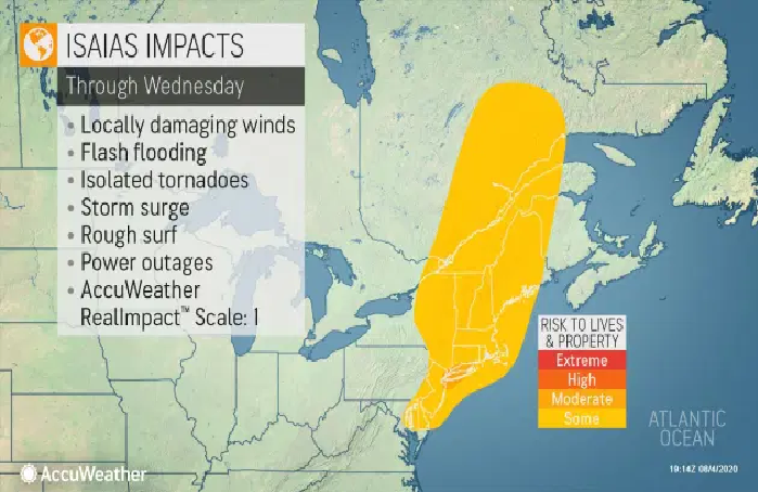
Florida is in the path of a potential tropical storm for the first time this hurricane season.
Residents could see heavy rain and strong winds from the system by the end of the week and into next week, according to the Florida Division of Emergency Management. It's still too early to determine where the storm might hit.
 |
| The projected path of what’s expected to become Tropical Storm Isaias Photo: National Hurricane Center |
Gov. Ron DeSantis said Wednesday that residents could feel the effects of the storm into early next week. He encouraged everyone to prepare now by having at least seven days of disaster supplies.
 |
| Photo: Accu Weather |
The weather system, which should soon be Tropical Storm Isaias, was dumping heavy rain across the Leeward Islands of the eastern Caribbean on Wednesday, potentially unleashing "life-threatening" flash flooding and mudslides. This includes Puerto Rico and the U.S. and British Virgin Islands, reported USA Today.
 |
| Photo: Accu Weather |
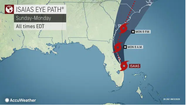
After moving near Puerto Rico on Wednesday night, the system will affect the Dominican Republic and Cuba before making its way to the U.S. mainland, possibly Florida, by the weekend.
The National Hurricane Center said the system, dubbed Potential Tropical Cyclone Nine, is expected to strengthen before it makes landfall in the Dominican Republic on Thursday, although the center cautioned it’s still unclear what the storm would do in upcoming days.
 |
| Photo: Accu Weather |
“The details of the long-range track and intensity forecasts remain more uncertain than usual since the system does not have a well-defined center and it is expected to move near or over portions of the Greater Antilles later this week and move near or over Florida this weekend,” the center said.
"While this system could bring some rainfall and wind impacts to portions of Cuba, the central and northwest Bahamas, and Florida later this week and this weekend, it is too soon to determine the location or magnitude of those impacts," the center added.
 |
| Photo: Accu Weather |
Tropical storm warnings were issued for Puerto Rico and the U.S. Virgin Islands.
Officials in Puerto Rico expressed concern about the potential for landslides and flooding and noted the U.S. territory is struggling with a spike in coronavirus cases while also still recovering from 2017’s devastating Hurricane Maria and a string of earthquakes earlier this year that damaged or destroyed hundreds of homes in the island’s south.
 |
| Photo: Accu Weather |
The governor said that more than 300 shelters across the island were prepared to receive people if needed and that more than 130,000 face masks were available.
If Isaias forms, it would be another record-breaker for a season that hasn’t even reached the typical peak of hurricane activity. The current record for the earliest “I”-named storm is Irene on Aug. 7, 2005.
 |
| A map shows the eight tropical systems that have developed in the Atlantic basin in 2020 so far and the tracks they took. Photo: AccuWeather |
It is reported by Accu Weather that winds on some of the islands will get strong enough to cause property damage, knock over trees, and lead to power outages.
"Some intensification is expected over the next couple of days with damaging wind gusts of 40-60 mph in the Windward Islands and 60-70 mph with an AccuWeather Local StormMax™ of 80 mph possible over Hispaniola," AccuWeather Senior Meteorologist Rob Miller stated.
“Rainfall amounts of 2-4 inches can be expected with 4-8 inches and an AccuWeather Local StormMax™ of 10 inches possible over any higher terrain," Miller added.
Interaction with the islands in the northern Caribbean, especially the mountainous terrain of the larger islands, is expected to exert a drag on the feature and could take the edge off the overall strength. Such a close track over the islands of the northern Caribbean would also raise the risk to lives and property from flooding rain, mudslides, and strong winds.
 |
| Photo: AccuWeather |
The high mountains on Hispaniola, and to some extent Puerto Rico and Cuba, act as a natural barrier to the path of the storm. Tropical systems generally avoid tracking over the heart of these islands as a result. However, the mountains can cause the center of an approaching tropical storm or hurricane to jump from one coast to the other and re-form in the process.
The overall strength of the system may also determine its fate as far as a track is concerned. Early on, a well-organized, stronger system is more likely to curve northwestward and northward faster than one which remains poorly organized and stays weak.
Canada weather forecast
This entire week is expected to hover around the 30°C mark in Calgary, and Environment Canada has continued that trend by renewing its official heat warning for the Calgary region for the third day in a row.
The warning was first issued on Monday morning, which was then echoed by the government agency on both Tuesday and Wednesday mornings, stating that temperatures are expected to reach 29°C or higher, reported Canadian environment.
Wednesday’s warning does predict an end to the heat, stating that “temperatures are forecast to be a few degrees cooler for most regions on Thursday.”
Calgarians should also be looking out for heatstroke in themselves and those around them, with symptoms including lack of sweat, confusion, fainting, high body temperatures, and unconsciousness.
The Thompson-Okanagan remains under a heat warning as temperatures continue to climb and Environment Canada is reminding everyone to stay safe.
"It is hot and we're expecting over the next couple of days to get into the high 30s, perhaps touching 40 in some locations like Osoyoos," says Environment Canada Meteorologist Doug Lundquist.
Yesterday, Osoyoos was the hot spot for not only B.C. but all of Canada, reaching a high of 37.9 C.
"Around [July] 31 to the first of August is the hottest two days of the year. This is the hottest week of the year usually on average," says Lundquist.
The Thompson Okanagan has not yet hit any record highs this week, but Lundquist says some areas could break records over the next two days.
 |
| The weather forecast in Montreal in the next five days Photo: Canadian environment |
In Montreal (July 30), it is forecast to be a mix of sun and cloud with 40 percent chance of showers and also the risk of a thunderstorm in the afternoon. Wind becoming west 20 km/h near noon. High 25. Humidex 30. UV index 7 or high. At night, it is likely to be partly cloudy and 40 percent chance of showers in the evening
 |
| The weather forecast in Ottawa in the next five days Photo: Canadian environment |
In Ottawa, it is forecast to be mainly cloudy and 60 percent chance of showers late in the morning and in the afternoon with risk of a thunderstorm. Fog patches dissipating in the morning. High 25. Humidex 29. UV index 5 or moderate. At night, it is likely to be cloudy with a 60 percent chance of showers early in the evening and risk of a thunderstorm. Clearing in the evening. Low 15.
 |
| The weather forecast in Calgary in the next five days Photo: Canadian environment |
In Calgary, it is clear in the morning. Wind northeast 20 km/h gusting to 40. High 26. Humidex 31. UV index 9 or very high. At night, it is likely to be mainly cloudy with a 30 percent chance of showers as well as the risk of a thunderstorm early in the evening. Wind northeast 20 km/h gusting to 40 becoming light in the evening.
 | |
|
 | |
|
 | US and Canada weather forecast today, July 11: Rare heatwave this weekend US and Canada weather forecast today, July 11: Parts of the southwestern United States are under an excessive heat warning this weekend. Temperatures are expected ... |
 | US and Canada weather forecast today, July 10: In the US, a shifting jet stream pattern into the weekend will bring temporary heat relief to ... |
 | US and Canada weather forecast today, July 9: Coast-to-Coast U.S. Heat Wave May Break Records US and Canada weather forecast today, July 9: Oppressive heat is forecasted to cover the U.S. from California to the Northeast through at least the ... |


Related Stories
 World
World
US and Canada weather forecast August 5: Tropical Storm Isaias ravages US East Coast, killing at least four
 World
World
US and Canada weather forecast August 3: Tropical Storm Isaias to ride Florida's east coast, could strike Carolinas as hurricane
 World
World
US and Canada weather forecast August 1: Hurricane Isaias heads toward Bahamas and Florida
 World
World
US and Canada weather forecast July 31: Tropical Storm Isaias forecast to become hurricane
Recommended
 World
World
Pakistan NCRC report explores emerging child rights issues
 World
World
"India has right to defend herself against terror," says German Foreign Minister, endorses Op Sindoor
 World
World
‘We stand with India’: Japan, UAE back New Delhi over its global outreach against terror
 World
World
'Action Was Entirely Justifiable': Former US NSA John Bolton Backs India's Right After Pahalgam Attack
Popular article
 World
World
US, China Conclude Trade Talks with Positive Outcome
 World
World
Nifty, Sensex jumped more than 2% in opening as India-Pakistan tensions ease
 World
World
Easing of US-China Tariffs: Markets React Positively, Experts Remain Cautious
 World
World