US and Canada weather forecast July 29: Potential Tropical Cyclone Nine has ominous track
US weather forecast
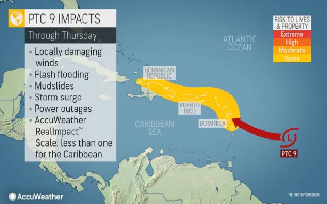
This prompted tropical storm warnings to be issued for Puerto Rico, Leeward Islands, and the Virgin Islands.
A tropical storm warning was issued for the Dominican Republic, from Cabo Caucedo to the northern border with Haiti.
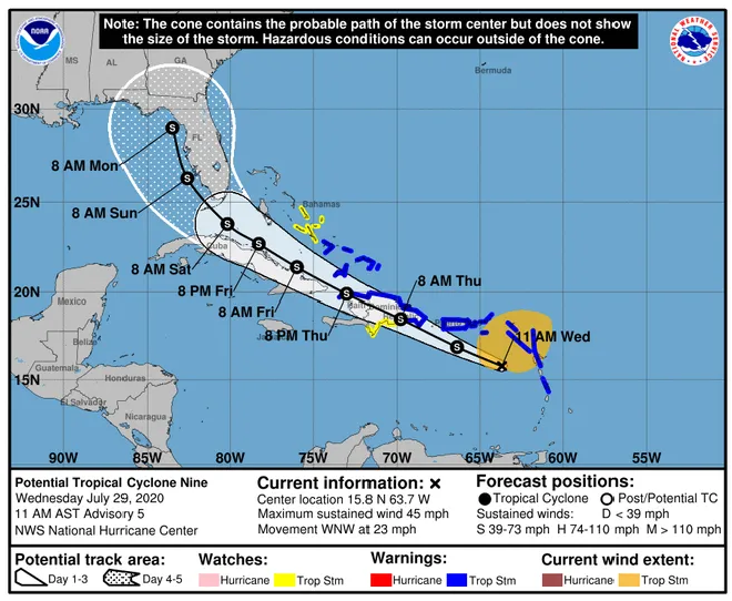
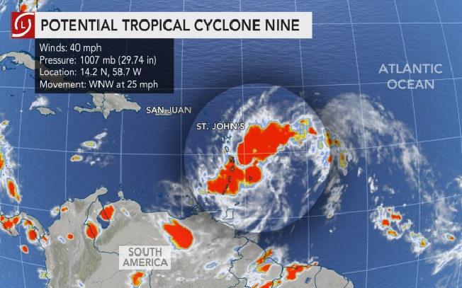
The storm on Tuesday evening was located 340 miles southeast of the Leeward Islands and was moving to the west-northwest at about 25 mph. It will impact the Leeward Islands by Wednesday and Puerto Rico by Wednesday night into Thursday, reported CNN.
 |
| Photo: Accuweather |
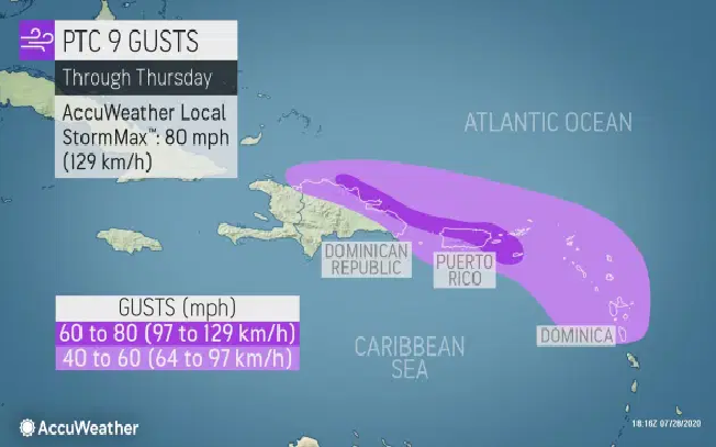
It is already delivering tropical-storm-force winds of 40 mph that extend 230 miles outward from the center of the storm system. The winds are forecast to increase in intensity.
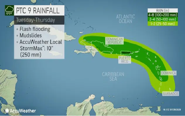
Rainfall amounts of 3 to 6 inches are likely, with locally up to 10 inches expected over the next few days across the Leeward Islands, Virgin Islands, and Puerto Rico. The heavy rain could lead to flash flooding and mudslides.
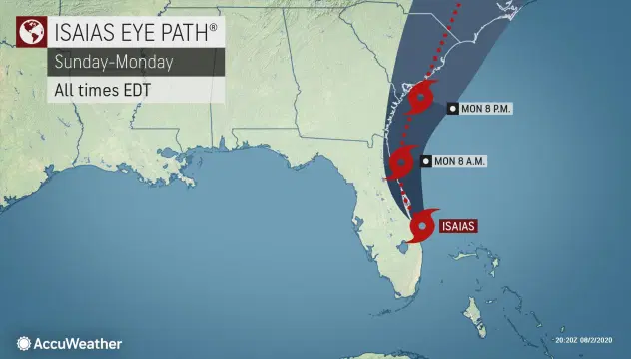
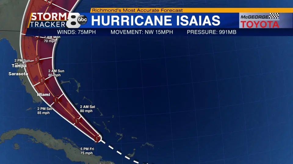
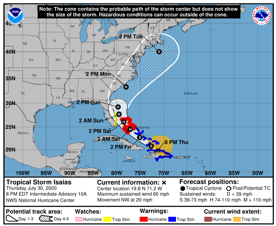
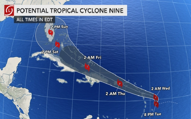
By Thursday morning, it will move through Puerto Rico at high-end tropical storm strength. It will continue to move through the southern Bahamas towards southern Florida by the end of the week. The southeastern U.S. must monitor the progression of this system for updates.
 |
| Photo: Accuweather |
It is informed by Accuse weather that unlike Gonzalo, which was a very compact storm that developed in a similar area, the thunderstorms associated with the area under investigation extends along a swath of ocean approximately 700 miles long. In comparison, Gonzalo's tropical-storm-force winds only extended across a distance of 50 miles.
 |
| Photo: Accuweather |
Despite the size of the budding system, there have been hurdles for it to overcome for development. And even though its 40-mph sustained winds met the criteria for a tropical storm, the system's lack of a well-defined center is keeping forecasters from upgrading it to a tropical storm status. However, it may soon enter an atmosphere with more favorable conditions for strengthening.
 |
| Photo: Accuweather |
"Moderate wind shear over the feature and dry air to its north has prevented the broad area of thunderstorms from becoming better organized the past few days," AccuWeather Senior Meteorologist Rob Miller said. Strong wind shear, or the changing of winds with altitude, can limit tropical development and even tear apart organized systems, causing them to weaken.
“As this feature moves briskly along to the west-northwest, wind shear is forecast to weaken, which should allow a better-defined center to take shape," Miller explained.
 |
| Photo: Accuweather |
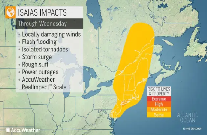
AccuWeather meteorologists expect the disturbance to become the storm of the 2020 Atlantic hurricane season. If it strengthens into a named storm, it would be called Isaias, pronounced ees-ah-ee-ahs. This name was added after Ike was retired in 2008 but has not yet been used. Should the tropical storm form prior to Aug. 7, it would set another early-formation record the season.
Should the center organize much farther south, then there is a more likely chance for the system to pass near or right over the islands of the northern Caribbean from the Lesser Antilles as well as Puerto Rico, Hispaniola, and Cuba later this week and this weekend, according to AccuWeather.
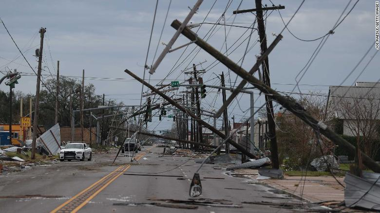
This land interaction, especially the mountainous terrain of the larger islands, would exert a drag on the feature and would tend to take the edge off the overall strength. Such a close track over the islands of the northern Caribbean would also raise the risk to lives and property from flooding rain, mudslides, and strong winds.
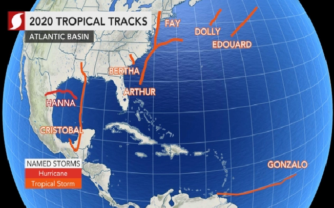 |
| A map shows eight tropical systems that have developed in the Atlantic basin in 2020 and the tracks they took. Photo: AccuWeather |
"A large portion of the Leeward Islands, Puerto Rico, and northern sections of the Dominican Republic should prepare for wind gusts of 40-60 mph, regardless of the exact track of the center," according to AccuWeather Meteorologist Randy Adkins.
AccuWeather Chief Broadcast Meteorologist Bernie Rayno also said that whether or not Florida sees impacts depends on whether the storm moves over Hispaniola, where he said it could fall apart. If it stays north of the island and maintains a circulation over water.
"Rainfall amounts of 2-4 inches will be common across the Lesser Antilles, Puerto Rico, and the Dominican Republic. Locally higher amounts of 4-8 inches with an AccuWeather Local StormMax™ of 10 inches are possible over the higher terrain, particularly over Puerto Rico. Flash flooding is likely to result in a number of areas with mudslides a threat along the hills and mountains," Adkins said.
Canada weather forecast
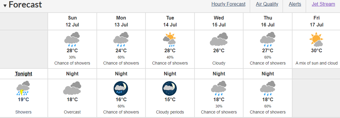
Seasonally hot for southern Ontario, though the closing days of July will feature the occasional storm risk.
 |
| Photo: The Weather Network |
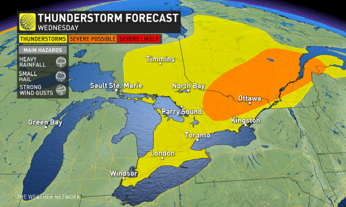
Ontario continues to see seasonally hot temperatures on Wednesday, but there is a chance of storm activity across the eastern and western borders. Storm risks include heavy downpours, strong winds, and possibly strong gusts, reported the Weather Network.
 |
| Photo: The Weather Network |
The storm risks start around noon around Ottawa. Southern Ontario gets to see some possible storm action around 2 - 4 pm, as the daytime heats kicks in. Areas that could see some severe storms are around Windsor, London, and into Niagara. Ottawa doesn't get a break from those risks, as they could see storms continue in the afternoon through the evening.
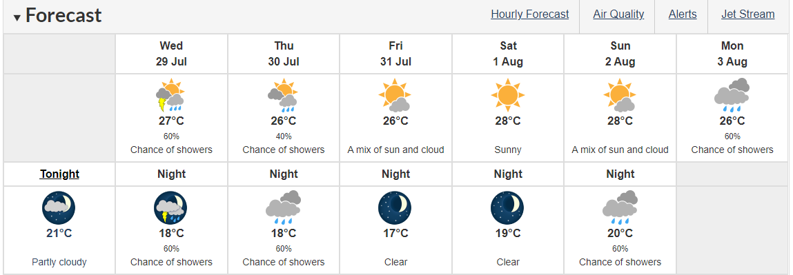 |
| The weather forecast in Montreal in the next five days Photo: Canadian environment |
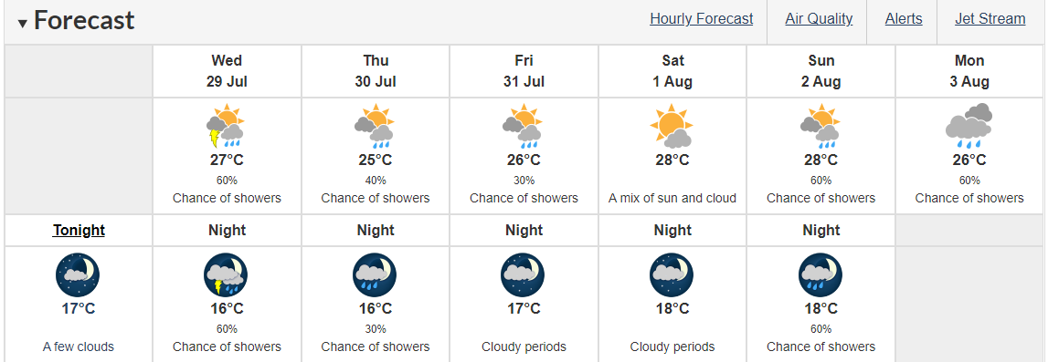 |
| The weather forecast in Ottawa in the next five days Photo: Canadian environment |
Any storms that do fire up will feature heavy downpours, strong winds, and possibly strong gusts.
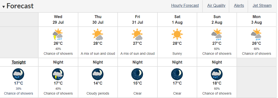 |
| The weather forecast in Toronto in the next five days Photo: Canadian environment |
The trigger will be a cold front sinking southward, and though the risk looks non-severe, the atmospheric setup is such that parts of eastern Ontario and cottage country have a chance of an isolated storm or two. With somewhat unsettled conditions for the rest of the week, there may be further chances for at least a few showers as we head to the weekend.
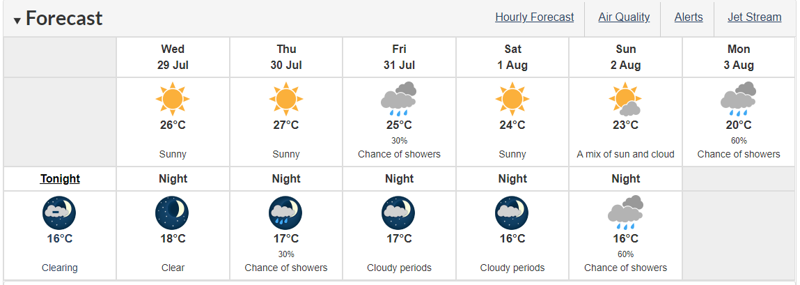 |
| The weather forecast in Vancouver in the next five days Photo: Canadian environment |
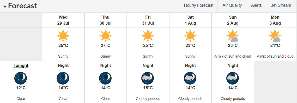 |
| The weather forecast in Victoria in the next five days Photo: Canadian environment |
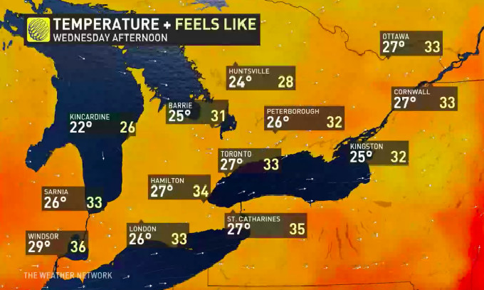
Temperature-wise, seasonal conditions look set to continue, at least through to the weekend. Wednesday features widespread daytime highs in the mid-to-high 20s, with the humidex in the mid-30s ... not cool by any means, but not uncomfortably hot.
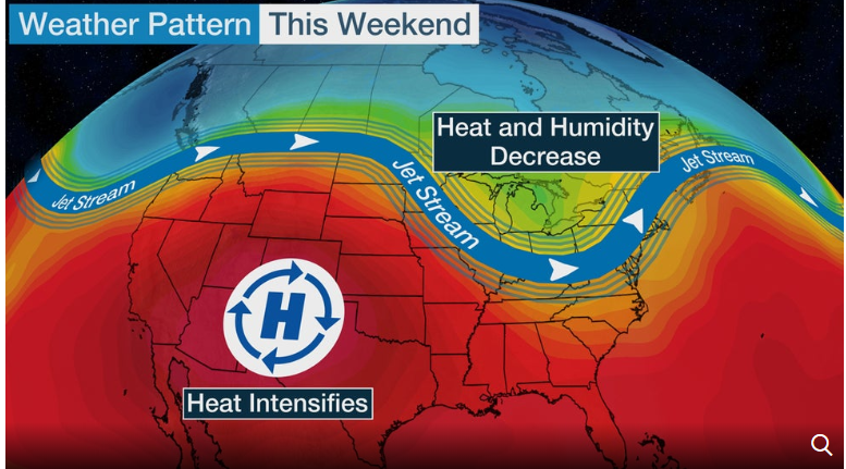 | US and Canada weather forecast today, July 10: In the US, a shifting jet stream pattern into the weekend will bring temporary heat relief to ... |
 | US and Canada weather forecast today, July 9: Coast-to-Coast U.S. Heat Wave May Break Records US and Canada weather forecast today, July 9: Oppressive heat is forecasted to cover the U.S. from California to the Northeast through at least the ... |
 | US and Canada weather forecast, today July 8: According to meteorologists, the hot weather will stay on through the rest of the month and maybe ... |
In topics
 World
World
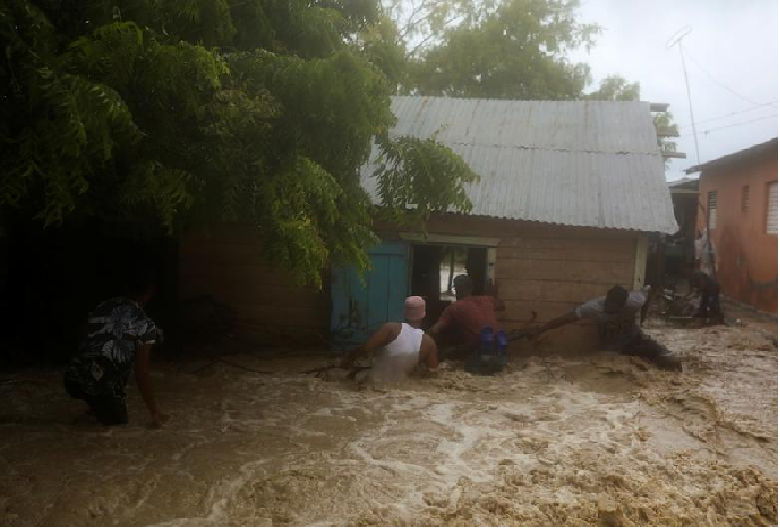
Storm Laura kills 11 in Dominican Republic and Haiti, sets course for US
Recommended
 World
World
Pakistan NCRC report explores emerging child rights issues
 World
World
"India has right to defend herself against terror," says German Foreign Minister, endorses Op Sindoor
 World
World
‘We stand with India’: Japan, UAE back New Delhi over its global outreach against terror
 World
World
'Action Was Entirely Justifiable': Former US NSA John Bolton Backs India's Right After Pahalgam Attack
Popular article
 World
World
US, China Conclude Trade Talks with Positive Outcome
 World
World
Nifty, Sensex jumped more than 2% in opening as India-Pakistan tensions ease
 World
World
Easing of US-China Tariffs: Markets React Positively, Experts Remain Cautious
 World
World

